
如果海洋枯竭,地球会是什么样子
NASA令人难以置信的模拟图显示,如果海洋枯竭,地球会是什么样子
Oceans cover most of the Earth, including its longest mountain range and the ancient bridges that humans crossed to reach other continents.
海洋覆盖了地球的大部分,覆盖地球最长的山脉和人类跨越到其他大陆的古老桥梁。
In a recent remake of a 2008 NASA video, planetary scientist James O'Donoghue shows what it would look like if all that water drained away, revealing the hidden three-fifths of Earth's surface.
在最近翻拍的美国宇航局2008年的一段视频中,行星科学家詹姆斯·奥·多诺休展示了如果所有的水都被抽干,地球表面将会是什么样子,从而揭示了隐藏的五分之三的地球表面。
O'Donoghue works at the Japan Aerospace Exploration Agency (JAXA) and was formerly at NASA. For the video, he took an animation that NASA physicist and animator Horace Mitchell created in 2008 and gave it a few additions. He edited the timing and added a tracker to show how much water drains throughout the animation.
O'Donoghue就职于日本宇宙航空研究开发机构(JAXA),之前在美国国家航空航天局工作。在这个视频中,他使用了美国宇航局物理学家和动画师贺拉斯·米切尔在2008年创作的一个动画,并添加了一些东西。他编辑了时间,并添加了一个跟踪器,以显示在整个动画中流失了多少水。
As the oceans slowly lose water, the first bits of hidden land that emerge are the continental shelves – the undersea edges of each continent.
随着海洋慢慢失去水分,最先出现的隐藏陆地是大陆架——每个大陆的海底边缘。
I slowed down the start since, rather surprisingly, there's a lot of undersea landscape instantly revealed in the first tens of meters, O'Donoghue told Business Insider in an email.
O'Donoghue在一封电子邮件中告诉记着:“我放慢了动画的速度,因为令人惊讶的是,在最初几十米的时候,很多海底景观立刻就显现出来了。”
The continental shelves include some of the land bridges that early humans crossed as they migrated from continent to continent. Tens of thousands of years ago, our ancestors could walk from continental Europe to the UK, from Siberia to Alaska, and from Australia to the islands surrounding it.
大陆架包括一些早期人类从一个大陆迁移到另一个大陆时穿过的陆桥。数万年前,我们的祖先从欧洲大陆走到英国,从西伯利亚走到阿拉斯加,从澳大利亚走到周围的岛屿。
When the last ice age occurred, a lot of ocean water was locked up as ice at the poles of the planet. That's why land bridges used to exist, O'Donoghue said. "Each of these links enabled humans to migrate, and when the ice age ended, the water sort of sealed them in."
“当最后一次冰河时代发生时,大量的海水在地球的两极凝结成冰。这就是陆桥曾经存在的原因。每一种联系都使人类得以迁移,当冰河时代结束时,海洋就把他们分割开来。”
By removing that water, the animation offers a glimpse at the world of our ancient ancestors.
通过移除海洋部分,动画让我们得以一窥我们远古祖先的世界。
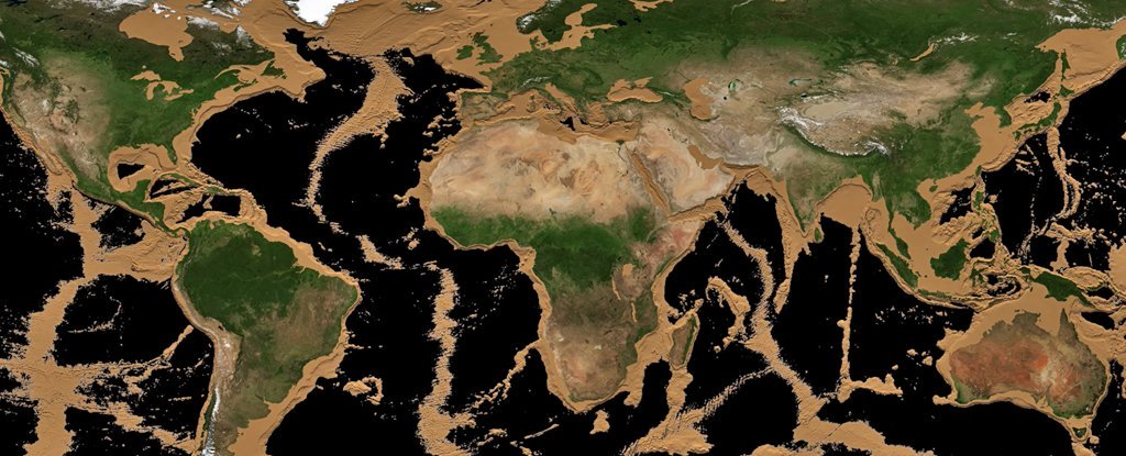
It also shows Earth's longest chain of mountains, which appears once the sea levels have dropped 2,000 to 3,000 meters (6,500 to 9,800 feet). That's the mid-ocean ridge, which stretches over 37,000 miles (60,000 kilometers) across the globe. Over 90 percent of it is underwater.
它还展示了地球上最长的山脉,当海平面下降2000到3000米(6500到9800英尺)时,山脉就出现了。那是大洋中脊,横跨全球超过37,000英里(60,000公里)。超过90%都在水下。
The volcanic mountains spring up at the seams where Earth's tectonic plates inch away from each other, creating new ocean floor as molten rock rises from beneath the plant's crust.
火山在地壳构造板块之间的缝隙处喷发,随着熔融岩石从地壳下升起,创造了新的海底。


